Pakistan’s space program, SUPARCO intends to launch five geostationary and six low earth orbit satellites between now and 2040.
Pakistan has the oldest space program in the Subcontinent named as SUPARCO But after lunar landings, it followed the global trend and shifted its focus to nuclear energy.
Humans have been looking at the stars, trying to unlock their mysteries for time immemorial. In ancient times, the celestial bodies that light up our night sky may have seemed as divine orbs controlling the fate of life on Earth but today, thanks to revolutionary advancements in science in the 20th century, human knowledge of the universe has expanded manifold. These advancements enabled United States (U.S.) astronaut Neil Armstrong to become the first human to step on the Moon. And with that first footstep, the dream of becoming a multiplanetary species was born.
There are 71 countries now with space agencies working towards this goal in one way or another. Six of these – the European Space Agency (ESA), the China National Space Administration (CNSA), the Japan Aerospace Exploration Agency (JAXA), the National Aeronautics and Space Administration (NASA), the Indian Space Research Organization (ISRO) and the Russian Federal Space Agency (RFSA or Roscosmos) have full launch capabilities. These include the ability to launch and recover multiple satellites, deploy cryogenic rocket engines, and operate extraterrestrial probes. Only three of these agencies – RFSA, CNSA, and NASA – are capable of human spaceflight.
From dreams to reality
Pakistan’s space program was born in the bipolar world of the Cold War between the U.S. and the Union of Soviet Socialist Republics (USSR). The foundations were laid thanks to the efforts of Pakistan’s only Nobel Laureate in Physics, Dr Abdus Salam, shortly after John F. Kennedy delivered his historic address in May 1961, announcing his administration’s ambitions to explore the frontiers of space. Sputnik I, the world’s first artificial satellite developed by the USSR, was already in orbit at that time.
In his memoir titled SUPARCO – The Formative Years (1961-1967), former federal secretary Tariq Mustafa recalls receiving a call from Professor Salam, who was advising then president Ayub Khan on the national space program. Salam asked him to meet him in Washington D.C. as soon as possible. The next morning, Mustafa joined Salam at the new headquarters of NASA. There, they met NASA’s director of international relations Arnold Frutkin, who did not waste time getting to the point. Frutkin informed them of NASA’s plan to take a manned flight to the Moon and to bring its crew back to Earth safely. He told them that this program would involve the entire planet as the rockets would have to be placed in orbit before being propelled towards the Moon.
The memoir narrates Frutkin’s conversation with Salam and Mustafa about the area above the Indian Ocean. The U.S. space agency felt that the area was a “black hole of data” since none was available for study.
NASA was inviting selected countries of the region to set up rocket ranges and carry out scientific experiments. An invitation was extended to Pakistan as well, and the agency committed to supplying free launching equipment and rockets.
On September 16, 1961, Pakistan’s Space and Upper Atmosphere Research Commission (SUPARCO) was established with Salam as its first director. In the same year, a number of scientists from Pakistan were sent to the U.S. for training in rocket launching. NASA was moving fast and Pakistan maintained the momentum. In the six months between September 1961 and March 1962, Pakistani scientists received intensive training at Wallops Island, Virginia, and in Karachi. It was during these sessions that plans were developed for design and layout of the rocket range and its infrastructure at Sonmiani, close to Karachi.
The Military Engineering Services was given the task of construction of the rocket range. NASA told Pakistan that the launcher and the rockets were based on the Nike Ajax anti-aircraft weapons system, whose components had been overproduced and lying in storage all over the U.S. Pakistan was allowed to take the Nike Booster Rocket from that system as well as some of the control instruments. It was decided that the first experiment – Sodium Vapour Trail experiment – which Pakistan was to fund on its own, would be conducted before the monsoon season in 1962.
India started testing its Thumba Range a few months later but could not launch until 1963.
By March 1962, the scientists in training were back in Karachi and began working for the first test. Rehbar-I was launched on June 7, 1962. By then, Pakistan was leading space research in South Asia, and 102 launches were conducted from Somniani Range between 1961 and 1972.
Winds of change
Tariq Mustafa’s memoir notes that in the years leading up to the Moon landing, Pakistan continued to carry out rocket borne upper atmospheric studies with NASA’s help. Other types of experiments based on exploding grenades and tracking of radar-reflective aluminum chaff in support of the Indian Ocean Program were also carried out by Pakistani space scientists.

Prof Salam and Dr Usmani stand beside Rehbar-I on June 7, 1962. COURTESY: The Friday Times
Soon, it was decided that the country would acquire technology to indigenously manufacture rockets and their propellants. However, the U.S. resisted, questioning the need for local production of rockets when they were being supplied free of cost by NASA. Pakistan then turned to France in the hopes of procuring such technology. A contract was signed with Sud-Aviation (subsequently known as Aerospatiale) of France for their Centaure/Dragon rockets and with the French Service des Poudres for their PVC type of rocket propellants. A rocket manufacturing plant was established near Mauripur, Karachi, using the services of Societe ENSA as consultants. The project was completed within three years in 1967 at a cost of $3 million. This culminated in the first Pakistani-built rocket named the Rehnuma, with the subsequent addition of the much larger Shahpar series, launched from Sonmiani from 1967 onwards on a regular basis.
Meanwhile, Apollo 11 undertook its successful mission to the Moon in 1969. Upon its return, however, the priorities of the global space effort began to change. The next big thing was the race for space stations.
Speaking to MIT Technology Review Pakistan, a faculty member at National University of Science and Technology (NUST) links the slowing down of Pakistan’s space research efforts with decreasing pace of space research in the world. “At one point, NASA was getting four percent of the U.S. national budget. Such heavy financing fell after the lunar landings. Other space agencies showed a similar trend.”
He says in Pakistan, SUPARCO was neglected after the moon landings. The priority at the national level shifted to atomic energy and a lot of manpower and financial support was diverted to the Pakistan Atomic Energy Commission (PAEC).
Space travel requires a distinction between manned and unmanned missions. Most missions to space are unmanned and the presence of humans in space is limited to space stations. “Pakistan has never aimed at travelling to space in a manned flight because that requires a completely different level of mission design than we have done so far,” he says.
In the 1980s, SUPARCO developed Badr-I, the country’s first digital communications satellite. It was joined by an Earth observation satellite, Badr II. Both have completed their missions.
Catching up
An important application of space is remote sensing. In textbook terms, it means a satellite, equipped with high definition imaging tools, is sent to space to observe the Earth. However, the same technique can be used for reconnaissance. In essence, space provides a vantage point for studying the Earth’s surface for strategic purposes: borders, troop movements, deployments etc.
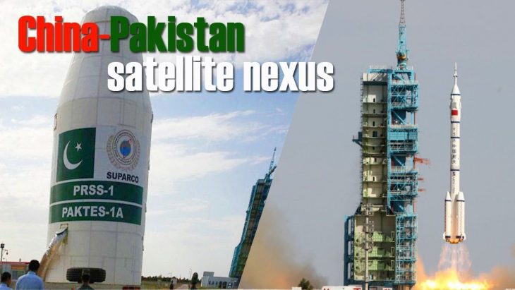
Another use of space is communication. Pakistan has one functional communication satellite, Pak-Sat 1R. It was launched into the space in 2011 with the help of China, replacing Pak-Sat 1E after the latter was decommissioned. The satellite is monitored from two ground stations: one near Islamabad and the other in Karachi.
Navigation is yet another major use of space. “A Global Navigation Satellite System (GNSS) is what we use when we need directions to a restaurant,” the NUST faculty member says. “We send a signal to space from our coordinates and it tells us where we are. Russia, China, and India each have their own GNSS. Currently, Pakistanis rely on the American system – the Global Positioning System – for our navigation needs.”
Navigation capabilities come in handy for various military purposes like tank and submarine movements and missile deployments. “In the time of conflict, if a country does not have their own satellite, they are vulnerable to sabotage.”
“A satellite is not complex – it requires a transmitter, receiver, and amplifier. we can easily make or buy these things. In fact, Pakistan is currently in the process of developing its own GNSS. Usually, three satellites in a constellation can cover the entire earth but for effective coverage, a GNSS needs 24 satellites.”
Under its Space Program 2040, the SUPARCO intends to launch five GEO satellites and six low earth orbit (LEO) satellites between now and 2040. In July 2011, then Prime Minister of Pakistan Yousaf Raza Gillani had officially approved the program.
A helping hand from space
At the 4th international conference on the use of space technology for water management held in Islamabad earlier this year, Qaiser Anees Khurrum, the serving chairman of SUPARCO, delineated contributions of the agency for various national development goals. He said, “SUPARCO has undertaken landmark projects such as development of geospatial systems for irrigation management, glaciers mapping and monitoring, river and flood vulnerability assessment, crop damage assessment, sea water intrusion mapping, and groundwater prospection.”
Prof. Dr. Allah Bakhsh from the University of Agriculture, Faisalabad, explained to MIT Technology Review Pakistan that previously the country used to obtain most of its upper atmospheric data from the Landsat satellite. Now we receive satellite images from the French government space agency’s SPOT satellite. This data is downloaded and then interpreted using various softwares such as ERDAS Imagine. “If there is a flood, we look at the satellite images to compare the area prior to the flood with the post-flood scenario. From that we determine how much area has been flooded. If that area had crops growing on it, then we determine how much crop has been damaged as well,” he says.
Satellites can also be used to track water resources and determine crop acreage. “Now it is possible to identify rainfall and other trends and its impact on humans as well as on agriculture and then take precautionary measures,” he says.
“When there was an earthquake in Pakistan’s northern area, it resulted in landsliding which blocked water streams. The blockage and the resultant formation of a lake was detected using remote sensing,” says Prof. Allah Bakhsh.
“If there are areas that are physically inaccessible, you can still carry out a survey and get data from those areas with the help of remote sensing. “You can also look at the impact of global warming and climate change,” he adds.
Glacier monitoring can be done by comparing the size of the glacier with what it used to be in the past. There are also studies being done on groundwater with the help of this space technology.
“For instance, I would say that there are areas along the river which are very fertile and there is water availability there too. So using this science, we can identify all such areas and plant high value crops over there.”
Prof. Allah Bakhsh says that SUPARCO has been very competent in communicating all the relevant information to other government ministries and departments so they can plan accordingly. For instance, timely information about the quantity of wheat grown in a year and the expected yield enables federal and provincial governments to balance supply and demand of wheat in the domestic market.
Similarly, satellites are widely used in identifying and forecasting natural disasters. In the case of a flood, remote sensing can be used to obtain useful information and alert people settled downstream.
“This helps with planning and is very useful, with less time and cost, you get better information,” Prof. Bakhsh says.
Muhammad Riaz, the chief meteorologist at the Flood Forecasting Division in the Pakistan Meteorological Department (PMD), says, “We use satellite imagery on a daily basis and not just in particular cases, because satellites provide us with a cheaper way to monitor the weather system.”
However, the Met department is not dependent on SUPARCO. It is a member of the World Meteorological Organization (WMO), an intergovernmental agency with 191 member states and territories. The organization promotes the availability and utilization of satellite data and promotes remote-sensing techniques to advance meteorology, hydrology, oceanography, and space weather applications.
“WMO is free for the availability of the data so we get it from them and from different satellites across the world,” Riaz says, explaining that this is necessary because the weather system encompansses the entire region, and cannot be monitored effectively with country-specific information.
“The floods that are coming are not just generated in our country. There are floods coming from outside the country from various river systems so they are cross-border phenomena. For example, the Kabul River is coming from the other side of the border in Pakistan,” he says.
Looking to the future
With regards to meteorology, Riaz says that there are a number of technologies that are very useful in weather monitoring and forecast, and could be acquired in the future. “Software is the most essential, like hydro-meteorological models or radars,” he says.
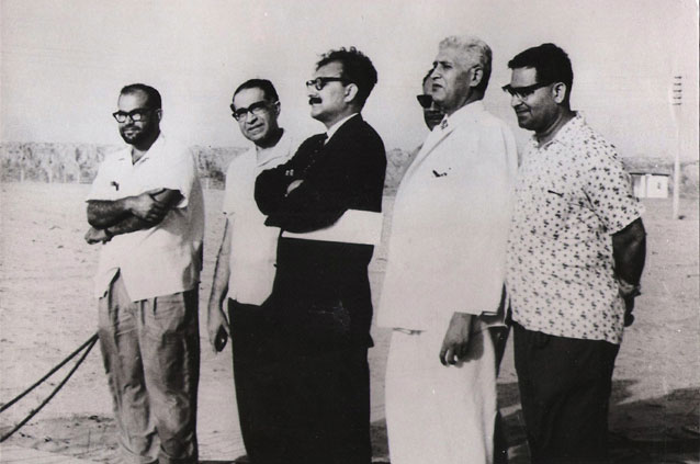
Left to Right: Tariq Mustafa, project leader; Dr. I. H. Usmani, chairman of PAEC; Prof. A. Salam, chairman of SUPARCO; Anis A. K. Shirwany, secretary of PAEC; and S. N. Naqvi, director, and M. Rahmatullah, regional director, of the Meteorology Department, respectively. COURTESY: The Friday Times
Prof. Bakhsh suggests that the Higher Education Commission (HEC) needs to bring space education and research within its ambit. “The softwares used in this sector are a little on the expensive side, and these should be made more widely available in the public sector,” he says. At school and college level, students should be taught more about remote sensing and space technologies because young people are quite interested in space sciences, he says. “This is the science of the future and if a few chapters are added on it in science textbooks, it would be quite useful for our future generation.”
“I would suggest that universities should have better satellite receiving stations so that the data that SUPARCO already downloads can be made available to universities for education and research purposes,” says Prof. Bakhsh, adding that training centers should be opened across higher education institutions so that students can learn how to comprehend and interpret the data.
Written by:
Aima Khosa, a former member of staff @ MIT Technology Review Pakistan
One thought on “Pakistan’s space program, SUPARCO intends to launch five geostationary and six low earth orbit satellites between now and 2040.”
Comments are closed.